When considering location tracking for important assets in your business, you will probably start by comparing it to the experience of using various location functionalities on a smartphone. For example, if you are an Apple user, you might have used the “Find My” app, which you can handily use to locate friends, devices, and personal items.

Similar applications exist for Android users. And you have probably already used an app for recording your sports activities or used it to navigate while taking a hike in nature or navigating a crowded city. v
All these different applications share one thing: they show pointers on a map – and most people would assume that this is only thanks to GPS, which seemingly can deliver 1-meter precision anywhere in the world. Is it that simple? It seems so. What is so special about location tracking, then?
To answer the question: What is the difference between smartphones and asset trackers when it comes to location tracking?
Read on to learn that although both asset trackers and smartphones harness very similar technologies, some very notable differences can help you understand what is possible, and what’s not, in the world of asset location tracking at scale.
Every smartphone uses GPS. What is it, exactly?
GPS, or Global Positioning System, is a global navigation satellite system that enables precise location tracking and accurate positioning of objects and individuals anywhere on Earth. It functions through a network of satellites that transmit signals in all directions.
When a GPS-capable device can “hear” the signals of multiple satellites at different positions in the sky, it can estimate its position by interpreting the combination of signals.

Technically speaking, we should talk about “GNSS” (Global Navigation Satellite System) to be correct, since this blanket term covers not only the American-made GPS but also for example the European Galileo system. But, for this article, we’ll just keep using the term GPS because everybody is familiar with it.
It’s important to understand that GPS localization is not something that can immediately provide 1-meter precision in a split second. Instead, smartphones listen for several seconds (even tens of seconds), and accuracy increases gradually as it averages out with repeated measurements. Only after a while, it will get to about 5-meter accuracy or slightly better.
My smartphone has a battery and GPS. A battery-powered asset tracker has a battery and GPS. Just the same, right?
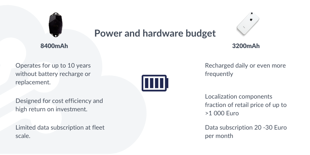
Yes, both trackers and smartphones use batteries. However, battery-powered trackers usually have similar, or greater battery capacity than high-end smartphones.

However, the key difference is in the design. These asset trackers should be able to run on the same batteries, without recharging or replacing them, for up to 10 years, depending on the configuration. The obvious reason is that replacing or recharging batteries is time-consuming and requires planning that would interrupt the regular logistics and business flows. It’s a costly and resource-heavy exercise if you are working with hundreds of trackers!
Compare that with smartphones that everybody effortlessly recharges every night. Sure, we care about having a smartphone that we can use for maybe 48 hours without recharging, so indeed the engineers think about power efficiency in smartphones. However, the power efficiency required for asset trackers to last many years is on a completely different level.
Is GPS the only way that a smartphone or tracker can know its location?
No! Although GPS technology is the most known, over the last 10-20 years several other geolocation technologies were also developed and integrated into smartphones.
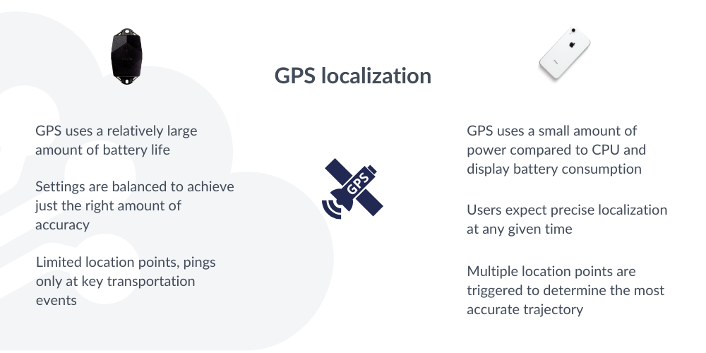
There are two main reasons why GPS isn’t the one location technology to rule them all. First, it doesn’t work indoors (more about this further in this article). Secondly, it’s quite energy consuming.


Another way to determine geographical locations is by scanning the unique fingerprint of Wi-Fi networks, knowing the location of cell towers of the communication network, or sensing the presence of geobeacons (which are devices that emit Bluetooth signals).
And, even more: apps on your smartphone will probably do some smart guessing by using context information. For example, if you are using a street map navigation app, then the smartphone can probably assume that you are on the street, and not 5 meters next to it.
Smartphones hide all these complexities from the users because regular users don’t need this level of detail. But the next time you see the words ‘enable location services’ on your smartphone, you know that’s because many geolocation technologies are involved.
And, for the same reason, a first-class battery-powered asset tracker is also capable of applying multiple geolocation techniques. Which techniques to use in what order, depends on the travel behavior of the assets, and can be remotely configured to produce the optimal balance between accuracy and power consumption (and battery lifetime).
Does a battery-powered tracker use the same 4G or 5G network as a smartphone?
Smartphones and battery-power trackers both need to communicate with the internet, otherwise, they are not useful. While they share some of the underlying communication technology and infrastructure, battery-powered trackers and smartphones typically use different cellular networks for communication.
Smartphones typically employ 3G, 4G, and 5G networks, offering high-speed data transfer for diverse needs.

On the other hand, asset location trackers are designed for efficiency, and they utilize specialized low-power communication networks like NB-IoT or LTE-M. The amount of data transmitted is much smaller compared to smartphones and doesn’t have to be transmitted with a few milliseconds of latency.
What are low-power communication networks?
Several Low-power communication networks, much like the evolution of 2G-3G-4G-5G, have emerged over the last 10 to 20 years. They facilitate remote device communication with minimal data requirements. In projects involving numerous remote devices, installing power lines and cables would be impractical. But also using the regular mobile networks of smartphones would drain the battery too fast while the high data speeds are not needed. For instance, monitoring water levels for potential city flooding or smart electricity meters at home only demands tiny volumes of data usage per device. These low-power communication networks also entail lower subscription costs per device compared to traditional mobile plans.
Various low-power area network (LPWAN) technologies, such as LoRa, Sigfox, LTE-M, and NB-IoT, exist. One difficulty is the roll-out of these networks worldwide takes time (similar to how the roll-out of 4G or 5G takes time). To navigate this landscape, consider partnering with experts like Sensolus. Their tracking solutions include communication subscriptions, simplifying the technical aspects, and ensuring efficient asset tracking.
My smartphone can show location indoors, even in a tunnel. So, GPS works indoors, right?
You have already had the impression that smartphones or other devices are often quite accurately localized indoors. For example, while navigating large covered public spaces like shopping malls or railroad stations, your location pointer seems to work fine.
And, when driving through a tunnel, your car’s GPS seems to work perfectly inside a mountain.

However, contrary to common perception, GPS fails to function indoors. For GPS localization, a device must capture signals from multiple satellites simultaneously. However, these signals are weaker than cell tower radio signals and are unable to penetrate walls and roofs. The fact that satellites are so much farther away than a cell tower explains why can make phone calls indoors, but GPS won’t work. So, how then do you get a localization in indoor environments?
Indoor localization, as observed in smartphone apps and car navigation within tunnels, relies on other technologies that are not known to many. Smartphones scan which Wi-Fi networks are nearby, and whose locations are mapped out by online location providers. Bluetooth geobeacons further aid indoor positioning, emitting unique signals for precise tracking. Though users encounter these features under “location services,” they remain concealed. There are strong commercial interests at play because smartphone location data is often used to present location-aware advertising to consumers.
Similarly, high-quality asset trackers employ multiple localization techniques beyond GPS, to ensure that both indoors and outdoors the location can be determined. Wi-Fi proves reliable, and prevalent in commercial and industrial areas. Geobeacons, lasting years, offer room-level indoor accuracy if needed.
Another advantage of these methods is the lower energy consumption compared to GPS, prolonging tracker life. Configuring a Sensolus tracker to prioritize energy-efficient techniques extends longevity while remote configuration and diagnostic tools enhance accuracy and battery optimization even after deployment. This exemplifies our commitment to maximizing customer investments.
Do I need the same amount of location data for asset tracking compared to smartphone navigation?
In fitness tracking, route navigation, or viewing friends’ locations, smartphones gather abundant location points for detailed and accurate location visualization. Real-time location updates are also vital for services like ridesharing and home deliveries. In general, most such applications would like to have as much location data as possible (because, as seen above, the concern about battery usage and data volume is not so high compared to other more power- or data-hungry applications).

However, in industrial tracking, constrained by battery and data limitations, such comprehensive tracking is neither feasible nor cost-effective. There is just no way to continuously deliver similar location update rates while also not requiring new batteries for so many years.
But, even if energy and resources were unlimited for asset trackers, would such copious location data truly optimize businesses? The answer is a resounding no. For most industrial cases, intricate trajectories hold little value. It would just be too much data than humans can process, or the data would need to be intelligently aggregated and post-processed.
Instead, meaningful insights arise from specific fleet-scale indicators, not intricate paths. Just as fitness progress is assessed through trends, like weekly activity averages, asset tracking’s essence lies in key events – movement initiation or destination arrival – not every minor detail.

Sensolus champions meaningful data over volume. Asset trackers intelligently update their location only when necessary, conserving battery and associating events with points. By adjusting update frequency during transit and stasis, these smart trackers provide contextual metadata. This context allows precise individual asset journey assessment, yielding valuable logistic metrics at the fleet level.
In the realm of Sensolus, location tracking is the art of gathering the right, impactful data rather than amassing data for its own sake.
Do Bluetooth tracking tags like Apple AirTag have a GPS?
Numerous brands offer consumer trackers like Apple AirTag, Samsung SmartTag, and Tile Pro/Mate/Slim, designed to prevent personal belongings from being misplaced. Despite displaying locations on smartphone maps, these tags lack independent GPS and internet connectivity. Instead, they emit unique Bluetooth signals, detected by nearby smartphones. This data, along with phone locations, aids online services in determining tag presence. Notably, indoor GPS limitations render most personal items untraceable.

An intriguing feature is smartphones collectively contributing to data location through crowdsourcing. Devices from the same vendor scan and report nearby tags, heightening the chance of recovery. For instance, an Apple AirTag or Samsung SmartTag could be picked up by someone else’s smartphone, aiding in retrieval. However, such solutions are closed systems, exclusive to specific vendors, and incompatible across ecosystems. This closed nature restricts industrial asset tracking applicability.
GPS trackers vs. Smartphones in summary:


